Trail Walking Le Dévoluy - Maniboux - Photo
 Marco05
Marco05

User GUIDE

© OpenStreetMap contributors
Length
Length
10.9 km
Max alt
Max alt
1635 m
Uphill gradient
Uphill gradient
447 m
Km-Effort
Km-Effort  
16.9 km
Min alt
Min alt
1224 m
Downhill gradient
Downhill gradient
447 m
Boucle
Boucle
Yes
Creation date :
2022-04-01 12:01:40.753
Updated on :
2022-11-01 13:08:59.58

(0 Reviews)

Walking
Walking
3h49
Difficulty : Medium

Scan this QR Code to open this trail in the SityTrail application

FREE GPS app for hiking

Logo SityTrail SityTrail

IGN / Geographical institutes

Download SityTrail from the App Store Download SityTrail from Google Play

Logo SityTrail SityTrail World

The world is yours!

Download SityTrail from the App Store Download SityTrail from Google Play Download SityTrail on Huawei AppGallery

About

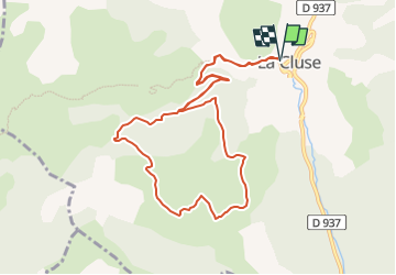
Trail Walking of 10.9 km to be discovered at Provence-Alpes-Côte d'Azur, Hautes-Alpes, Le Dévoluy. This trail is proposed by Marco05.

Description

Une randonnée très sympa au départ de la Cluses dans le Dévoluy.
Aucune difficulté.
Accessiible aux randonneurs moyens.

Elevation profile

Photos

Positioning

Country:
France
Region :
Provence-Alpes-Côte d'Azur
Department/Province :
Hautes-Alpes
Municipality :
Le Dévoluy
Location:
Unknown
Start:(UTM)
725789 ; 4946860 (31T) N.

Trails nearby

Trail Walking Le Dévoluy - R13   Le Col de Lauteret - Photo
Walking
GUIDE+

Walking

Medium
(1)
Le Dévoluy, Provence-Alpes-Côte d'Azur, Hautes-Alpes, France
8.5 km | 15.9 km-effort
3h 12min
Yes
Trail Walking Le Dévoluy - R12   Le Col des Aiguilles - Photo
Walking
GUIDE+

Walking

Medium
(1)
Le Dévoluy, Provence-Alpes-Côte d'Azur, Hautes-Alpes, France
10.2 km | 19.2 km-effort
3h 56min
Yes
Trail Walking Le Dévoluy - R11   Cabane Rama - Photo
Walking
GUIDE+

Walking

Very easy
(4)
Le Dévoluy, Provence-Alpes-Côte d'Azur, Hautes-Alpes, France
5.5 km | 8.4 km-effort
1h 46min
Yes
Trail Walking Le Dévoluy - Cascade de Saute Aure - Photo
Walking
marmotte83

Walking

Easy
(3)
Le Dévoluy, Provence-Alpes-Côte d'Azur, Hautes-Alpes, France
7.7 km | 10.8 km-effort
3h 1min
Yes
Trail Walking Le Dévoluy - suuntoapp-Hiking-2024-06-17T07-23-45Z - Photo
Walking
GUIDE
Marco05

Walking

Difficult
Le Dévoluy, Provence-Alpes-Côte d'Azur, Hautes-Alpes, France
9.6 km | 17.9 km-effort
4h 4min
Yes
Trail Walking Le Dévoluy - Tête de Garnesier - Photo
Walking
GUIDE
Marco05

Walking

Very difficult
Le Dévoluy, Provence-Alpes-Côte d'Azur, Hautes-Alpes, France
11.5 km | 26 km-effort
5h 57min
Yes
Trail Walking Montmaur - Pic de Bure par combe d'Aurouze - Photo
Walking
GUIDE
Marco05

Walking

Very difficult
Montmaur, Provence-Alpes-Côte d'Azur, Hautes-Alpes, France
14.1 km | 33 km-effort
7h 24min
Yes
Trail Walking Le Dévoluy - Col des Aiguilles - Photo
Walking
GUIDE
Marco05

Walking

Difficult
Le Dévoluy, Provence-Alpes-Côte d'Azur, Hautes-Alpes, France
11.3 km | 21 km-effort
4h 46min
Yes
Trail Walking Montmaur - Col de Conode - Photo
Walking
GUIDE
Marco05

Walking

Medium
Montmaur, Provence-Alpes-Côte d'Azur, Hautes-Alpes, France
14.2 km | 22 km-effort
4h 58min
Yes


Close
My subscriptions